
PROFESSIONAL AERIAL TOPOGRAPHY, MAPPING AND INDUSTRIAL SERVICES
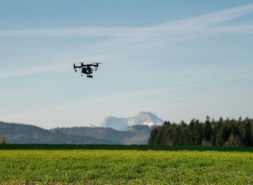
Cutting-edge drone technology allows us to create and deliver advanced, time-saving products to a variety of industries. The benefits of using UAVs are unmatched by anything else with speed & efficiency, high-resolution cameras for detailed images, crew safety, and RTK (Real Time Kinematic) precision. Drone data is integrated across many industries in usable formats like photos and videos, ortho-mosaic photos, DSM’s (Digital Surface Model), CAD drawings, topographic surveys, and thermal & multispectral analysis. Whether you need eye-catching images for marketing, a virtual flyover to showcase your listing, a large topographic survey, or progress updates, drones are changing the game.
The Sky Is The Limit
UNMATCHED EFFICIENCY, SAFETY, AND ACCURACY
As the old saying goes, “time is money” and that certainly still holds true in today’s fast paced environment. We save time and money by deploying the latest drone technology with high resolution 4K cameras, which allows us to provide a cost-effective solution to your aerial imaging needs. Our drones are ideal for marketing and development, infrastructure inspections, square footage and volumetric calculations, site monitoring, construction progress, 3D modeling, and much more. For survey projects our RTK module will ensure survey grade accuracy with precise elevation models and imagery. With fast turnaround time drones provide valuable insights and a competitive advantage not had by those using conventional methods of data collection. Leave the technical challenges, FAA compliance filings, and data crunching up to us so you can sit back and focus on what you do best. Discover the benefits of drone technology when your project in expert hands.

Experience, Precision, and Innovation
Our services go well beyond strictly visuals. It’s a symbiotic blend of cutting-edge technology, extensive experience, and a labor-of-love for the craft that sets us apart from the other guys and nation wide companies. Our Pilots are FAA certified and very familiar with the local airspace rules and regulations. Whether you’re in real estate and want to engage more prospects, a home/building inspector trying to get a better visual, an architect in need of a CAD surface with an orthophoto, or just want to capture that special event, SDC is your local drone professional.
Featured Services
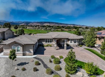
Stunning Aerial Perspectives
Increased Buyer Engagement
Faster Property Sales
Cost-Effective Marketing Strategy
Enhanced Digital Integration
Showcase Property Layout & Landscaping
Boost Listing Visibility
Proven Marketing Success

Improved Planning Accuracy
Real-Time Site Monitoring
Cost-Effective Construction Solutions
Comprehensive Project Documentation
Enhanced Safety & Risk Reduction
Reduced Environmental Impact
Seamless Data Integration
Versatile Construction Applications
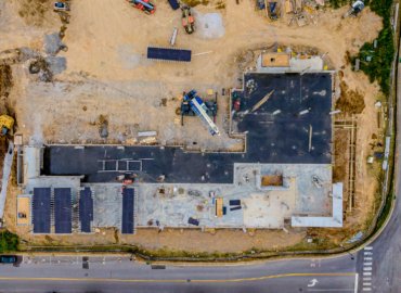
Real-Time Progress Tracking
Enhanced Safety & Risk Reduction
Efficient Resource Management
Cost-Effective Monitoring Solutions
Accurate Volume Calculations
Regulatory Compliance Support
Comprehensive Site Documentation
Versatile Industry Applications

Enhanced Safety & Risk Reduction
Faster & More Efficient Inspections
Significant Cost Savings
High-Resolution Data Collection
Versatile Across Multiple Industries
Real-Time Monitoring & Analysis
Access Hard-to-Reach Areas with Ease
Innovative & Future-Ready Solutions
Enhanced Crop Monitoring
Increased Efficiency
Cost-Effective Solutions
Data-Driven Decision Making
Precise Field Management
Environmental Benefits
Versatility in Applications
Real-Time Feedback
Operating Area
We currently operate in the South Lake Tahoe/Reno area. Businesses outside of a 30 mile radius may require travel expenses. Please contact for more details.
We Love our Clients, And They Love Us
Recent Posts
Transforming Land Development with Advanced LIDAR Drone Mapping in Northern Nevada In the rugged landscapes of Northern Nevada, where steep slopes meet pristine lakes and valleys stretch toward snow-capped peaks, land development has always presented unique challenges. Traditional surveying methods struggle to capture the complex terrain efficiently, often resulting in delays, cost overruns, and incomplete data. Enter the revolutionary world…
Enhancing Construction Site Monitoring with Drone Technology In the rapidly evolving landscape of construction management, innovative technologies are revolutionizing traditional approaches to site monitoring and oversight. Among these advancements, drone technology has emerged as a game-changer for construction professionals seeking to improve safety standards, track progress with unprecedented accuracy, and optimize resource allocation. At Sierra Drone Concepts in Gardnerville, Carson…
Introduction Drone services Carson Valley are advancing rapidly, revolutionizing photography, inspection, surveying, and more. Particularly in scenic areas like Carson Valley and Lake Tahoe, drone technology is not only taking flight—it’s reshaping entire industries. From real estate and construction to agriculture and emergency response, the future of drone services in this part of Nevada is bright and full of promise.…